This website is the digital version of the 2014 National Climate Assessment, produced in collaboration with the U.S. Global Change Research Program.

For the official version, please refer to the PDF in the downloads section. The downloadable PDF is the official version of the 2014 National Climate Assessment.

Credits | Site Map

Search Options

X

Search form

Top

Welcome to the National Climate Assessment

The National Climate Assessment summarizes the impacts of climate change on the United States, now and in the future.

A team of more than 300 experts guided by a 60-member Federal Advisory Committee produced the report, which was extensively reviewed by the public and experts, including federal agencies and a panel of the National Academy of Sciences.

Explore the effects of climate change
United States Global Change Research Program logo
United States Department of Agriculture logo United States Department of Commerce logo United States Department of Defense logo United States Department of Energy logo United States Department of Health and Human Services logo United States Department of the Interior logo United States Department of State logo United States Department of Transportation logo United States Environmental Protection Agency logo National Aeronautics and Space Administration logo National Science Foundation logo Smithsonian Institution logo United States Agency for International Development logo

Precipitation Change

Average U.S. precipitation has increased since 1900, but there are regional differences, with some areas having larger increases, and others, decreases. More winter and spring precipitation is projected for the northern U.S., and less for the Southwest.

Explore U.S. precipitation changes.

Next

Convening Lead Authors

John Walsh, University of Alaska Fairbanks

Donald Wuebbles, University of Illinois

Lead Authors

Katharine Hayhoe, Texas Tech University

James Kossin, NOAA, National Climatic Data Center

Kenneth Kunkel, CICS-NC, North Carolina State Univ., NOAA National Climatic Data Center

Graeme Stephens, NASA Jet Propulsion Laboratory

Peter Thorne, Nansen Environmental and Remote Sensing Center

Russell Vose, NOAA National Climatic Data Center

Michael Wehner, Lawrence Berkeley National Laboratory

Josh Willis, NASA Jet Propulsion Laboratory

Contributing Authors

David Anderson, NOAA, National Climatic Data Center

Scott Doney, Woods Hole Oceanographic Institution

Richard Feely, NOAA Pacific Marine Environmental Laboratory

Paula Hennon, CICS-NC, North Carolina State Univ., NOAA National Climatic Data Center

Viatcheslav Kharin, Canadian Centre for Climate Modelling and Analysis, Environment Canada

Thomas Knutson, NOAA Geophysical Fluid Dynamics Laboratory

Felix Landerer, NASA Jet Propulsion Laboratory

Tim Lenton, Exeter University

John Kennedy, UK Meteorological Office

Richard Somerville, Scripps Institution of Oceanography, Univ. of California, San Diego

Introduction

This chapter summarizes how climate is changing, why it is changing, and what is projected for the future. While the focus is on changes in the United States, the need to provide context sometimes requires a broader geographical perspective. Additional geographic detail is presented in the regional chapters of this report. Further details on the topics covered by this chapter are provided in the Climate Science Supplement and Frequently Asked Questions Appendices.

The chapter presents 12 key messages about our changing climate, together with supporting evidence for those messages. The discussion of each key message begins with a summary of recent variations or trends, followed by projections of the corresponding changes for the future.

Key Message 5: U.S. Precipitation Change

Average U.S. precipitation has increased since 1900, but some areas have had increases greater than the national average, and some areas have had decreases. More winter and spring precipitation is projected for the northern United States, and less for the Southwest, over this century.

Supporting Evidence
close

Supporting Evidence

Process for Developing Key Messages

Development of the key messages involved discussions of the lead authors and accompanying analyses conducted via one in-person meeting plus multiple teleconferences and email exchanges from February thru September 2012. The authors reviewed 80 technical inputs provided by the public, as well as other published literature, and applied their professional judgment.

Key message development also involved the findings from four special workshops that related to the latest scientific understanding of climate extremes. Each workshop had a different theme related to climate extremes, had approximately 30 attendees (the CMIP5 meeting had more than 100), and the workshops resulted in a paper.7 The first workshop was held in July 2011, titled Monitoring Changes in Extreme Storm Statistics: State of Knowledge.8 The second was held in November 2011, titled Forum on Trends and Causes of Observed Changes in Heatwaves, Coldwaves, Floods, and Drought.3 The third was held in January 2012, titled Forum on Trends in Extreme Winds, Waves, and Extratropical Storms along the Coasts.9 The fourth, the CMIP5 results workshop, was held in March 2012 in Hawai‘i, and resulted in an analysis of CMIP5 results relative to climate extremes in the United States.7

The Chapter Author Team’s discussions were supported by targeted consultation with additional experts. Professional expertise and judgment led to determining “key vulnerabilities.” A consensus-based approach was used for final key message selection.

Description of evidence base

The key message and supporting text summarizes extensive evidence documented in the climate science peer-reviewed literature. Technical Input reports (82) on a wide range of topics were also reviewed; they were received as part of the Federal Register Notice solicitation for public input.

Evidence of long-term change in precipitation is based on analysis (for example, Kunkel et al. 20131) of daily observations from the U.S. Cooperative Observer Network. Published work shows the regional differences in precipitation.2,3 Evidence of future change is based on our knowledge of the climate system’s response to heat-trapping gases and an understanding of the regional mechanisms behind the projected changes (for example, IPCC 20074).

New information and remaining uncertainties

A key issue (uncertainty) is the sensitivity of observed precipitation trends to historical changes in station location, rain gauges, and observing practice. A second key issue is the ability of climate models to simulate precipitation. This is one of the more challenging aspects of modeling of the climate system, because precipitation involves not only large-scale processes that are well-resolved by models but small-scale process, such as convection, that must be parameterized in the current generation of global and regional climate models. However, our understanding of the physical basis for these changes has solidified and the newest set of climate model simulations (CMIP5) continues to show high-latitude increases and subtropical decreases in precipitation. For most of the contiguous U.S., studies5,6 indicate that the models currently do not detect a robust anthropogenic influence to observed changes, suggesting that observed changes are principally of natural origins. Thus, confident projections of precipitation changes are limited to the northern and southern areas of the contiguous U.S. that are part of the global pattern of observed and robust projected changes that can be related to anthropogenic forcing. Furthermore, for the first time in the U.S. National Climate Assessment, a confidence statement is made that some projected precipitation changes are deemed small. It is incorrect to attempt to validate or invalidate climate model simulations of observed trends in these regions and/or seasons, as such simulations are not designed to forecast the precise timing of natural variations.

Shifts in precipitation patterns due to changes in other sources of air pollution, such as sulfate aerosols, are uncertain and are an active research topic.

Viable avenues to improving the information base are to investigate the sensitivity of observed trends to potential biases introduced by station changes, and to investigate the causes of observed regional variations.

A number of peer-reviewed studies (for example, McRoberts and Nielsen-Gammon 2011; Peterson et al. 20132,3) document precipitation increases at the national scale as well as regional-scale increases and decreases. The variation in magnitude and pattern of future changes from climate model simulations is large relative to observed (and modeled) historical variations.

Assessment of confidence based on evidence

Given the evidence base and remaining uncertainties, confidence is high that average U.S. precipitation has increased since 1900, with some areas having had increases greater than the national average, and some areas having had decreases.

Confidence is high, given the evidence base and uncertainties, that more winter and spring precipitation is projected for the northern U.S., and less for the Southwest, over this century in the higher emissions scenarios. Confidence is medium that human-induced precipitation changes will be small compared to natural variations in all seasons over large portions of the U.S. in the lower emissions scenarios. Confidence is medium that human-induced precipitation changes will be small compared to natural variations in the summer and fall over large portions of the U.S. in the higher emissions scenarios.

Confidence Level

Very High

Strong evidence (established theory, multiple sources, consistent results, well documented and accepted methods, etc.), high consensus

High

Moderate evidence (several sources, some consistency, methods vary and/or documentation limited, etc.), medium consensus

Medium

Suggestive evidence (a few sources, limited consistency, models incomplete, methods emerging, etc.), competing schools of thought

Low

Inconclusive evidence (limited sources, extrapolations, inconsistent findings, poor documentation and/or methods not tested, etc.), disagreement or lack of opinions among experts

U.S. Precipitation Change

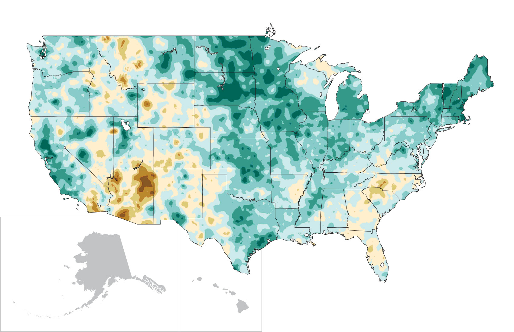
Since 1900, average annual precipitation over the U.S. has increased by roughly 5%. This increase reflects, in part, the major droughts of the 1930s and 1950s, which made the early half of the record drier. There are important regional differences. For instance, precipitation since 1991 (relative to 1901-1960) increased the most in the Northeast (8%), Midwest (9%), and southern Great Plains (8%), while much of the Southeast and Southwest had a mix of areas of increases and decreases.2,3

Figure 2.12: Observed U.S. Precipitation Change

Observed U.S. Precipitation Change

U.S. AverageAlaskaNorthwestSouthwestHawai'iGreat Plains NorthGreat Plains SouthMidwestNortheastSoutheast
Alaska Northwest Southwest Hawai'i Great Plains North Great Plains South Southeast Northeast Midwest
Close

U.S. Average

Close

Alaska

Close

Northwest

Close

Southwest

Close

Hawai'i

Close

Great Plains North

Close

Great Plains South

Close

Midwest

Close

Northeast

Close

Southeast

Figure 2.12: The colors on the map show annual total precipitation changes for 1991-2012 compared to the 1901-1960 average, and show wetter conditions in most areas. The bars on the graphs show average precipitation differences by decade for 1901-2012 (relative to the 1901-1960 average) for each region. The far right bar in each graph is for 2001-2012. (Figure source: adapted from Peterson et al. 20133).

Details/Download

While significant trends in average precipitation have been detected, the fraction of these trends attributable to human activity is difficult to quantify at regional scales because the range of natural variability in precipitation is large. Projected changes are generally small for central portions of the United States. However, if emissions of heat-trapping gases continue their upward trend, certain global patterns of precipitation change are projected to emerge that will affect northern and southwestern areas of the United States. The northern U.S. is projected to experience more precipitation in the winter and spring (except for the Northwest in the spring), while the Southwest is projected to experience less, particularly in the spring. The contrast between wet and dry areas will increase both in the U.S. and globally – in other words, the wet areas will get wetter and the dry areas will get drier. As discussed in the next section, there has been an increase in the amount of precipitation falling in heavy events10,11 and this is projected to continue.

The projected changes in the northern U.S. are a consequence of both a warmer atmosphere (which can hold more moisture than a colder one) and associated changes in large-scale weather patterns (which affect where precipitation occurs). The projected reduction in Southwest precipitation is a result of changes in large-scale weather patterns, including the northward expansion of the belt of high pressure in the subtropics, which suppresses rainfall. Recent improvements in understanding these mechanisms of change increase confidence in these projections.12 The patterns of the projected changes of precipitation resulting from human alterations of the climate are geographically smoother in these maps than what will actually be observed because: 1) the precise locations of natural increases and decreases differ from model to model, and averaging across models smooths these differences; and 2) the resolution of current climate models is too coarse to capture fine topographic details, especially in mountainous terrain. Hence, there is considerably more confidence in the large-scale patterns of change than in local details.

Uncertainties in Regional Projections

On the global scale, climate model simulations show consistent projections of future conditions under a range of emissions scenarios. For temperature, all models show warming by late this century that is much larger than historical variations nearly everywhere. For precipitation, models are in complete agreement in showing decreases in precipitation in the subtropics and increases in precipitation at higher latitudes.

Models unequivocally project large and historically unprecedented future warming in every region of the U.S. under all of the scenarios used in this assessment. The amount of warming varies substantially between higher versus lower scenarios, and moderately from model to model, but the amount of projected warming is larger than the model-to-model range.

The contiguous U.S. straddles the transition zone between drier conditions in the sub-tropics (south) and wetter conditions at higher latitudes (north). Because the precise location of this zone varies somewhat among models, projected changes in precipitation in central areas of the U.S. range from small increases to small decreases. A clear direction of change only occurs in Alaska and the far north of the contiguous U.S. where increases are projected and in the far Southwest where decreases are projected.

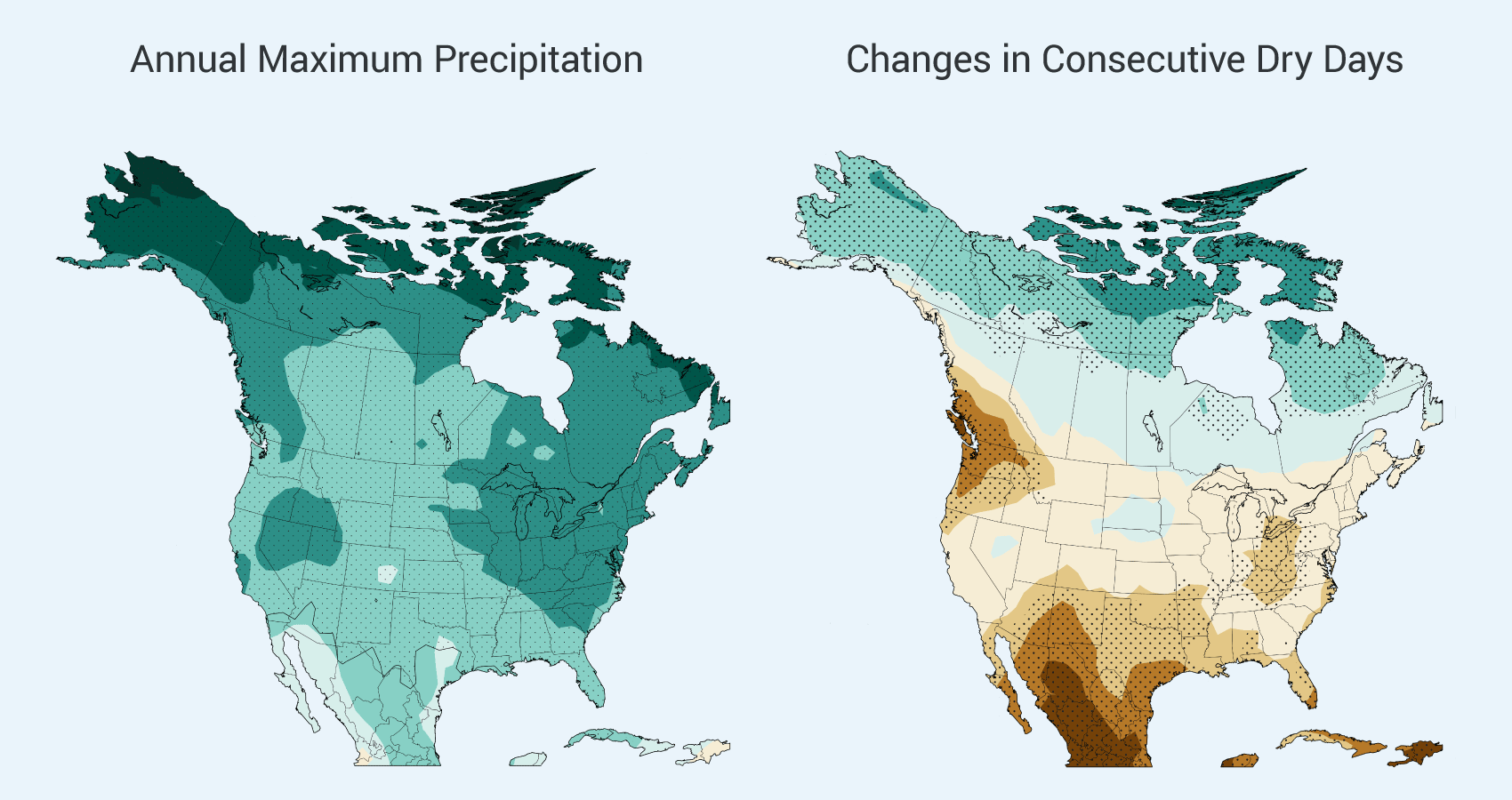
Figure 2.13: Annual Maximum Precipitation

Regional Uncertainty

Rapid Emissions Reductions (RCP 2.6)Continued Emissions Increases (RCP 8.5)

Figure 2.13: Left panel shows simulated changes in the average amount of precipitation falling on the wettest day of the year for the period 2070-2099 as compared to 1971-2000 under a scenario that assumes rapid reductions in emissions (RCP 2.6) and one that assumes continued emissions increases (RCP 8.5). Right panel shows simulated changes in the annual maximum number of consecutive dry days (days receiving less than 0.04 inches (1 mm) of precipitation) under the same two scenarios. Simulations are from CMIP5 models. Stippling indicates areas where changes are consistent among at least 80% of the models used in this analysis. (Figure source: NOAA NCDC / CICS-NC).

Details/Download

Although this means that changes in overall precipitation are uncertain in many U.S. areas, there is a high degree of certainty that the heaviest precipitation events will increase everywhere, and by large amounts (Figure 2.13). This consistent model projection is well understood and is a direct outcome of the increase in atmospheric moisture caused by warming. There is also more certainty regarding dry spells. The annual maximum number of consecutive dry days is projected to increase in most areas, especially the southern and northwestern portions of the contiguous United States. Thus, both extreme wetness and extreme dryness are projected to increase in many areas.

Modeling methods that downscale (generate higher spatial resolution) climate projections from coarser global model output can reduce the range of projections to the extent that they incorporate better representation of certain physical processes (such as the influence of topography and convection). However, a sizeable portion of the range is a result of the variations in large-scale patterns produced by the global models and so downscaling methods do not change this.

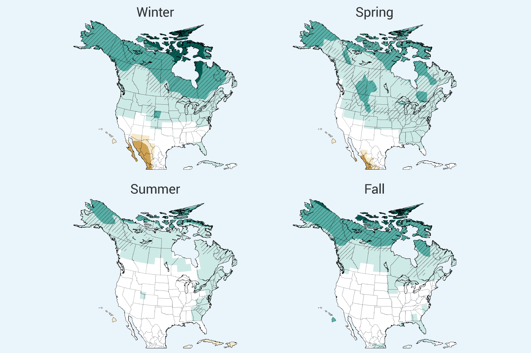
Figure 2.14: Projected Precipitation Change by Season Projected Precipitation Change by Season Details/Download

In general, a comparison of the various sources of climate model data used in this assessment provides a consistent picture of the large-scale projected precipitation changes across the United States (see “Models Used in the Assessment”). Multi-model average changes in all three of these sources show a general pattern of wetter future conditions in the north and drier conditions in the south. The regional suite generally shows conditions that are somewhat wetter overall in the wet areas and not as dry in the dry areas. The general pattern agreement among these three sources, with the wide variations in their spatial resolution, provides confidence that this pattern is robust and not sensitive to the limited spatial resolution of the models. The slightly different conditions in the North American NARCCAP regional analyses for the U.S. appear to arise partially or wholly from the choice of the four CMIP3 global climate models used to drive the regional simulations. These four global models, averaged together, project average changes that are 2% wetter than the average of the suite of global models used in CMIP3.

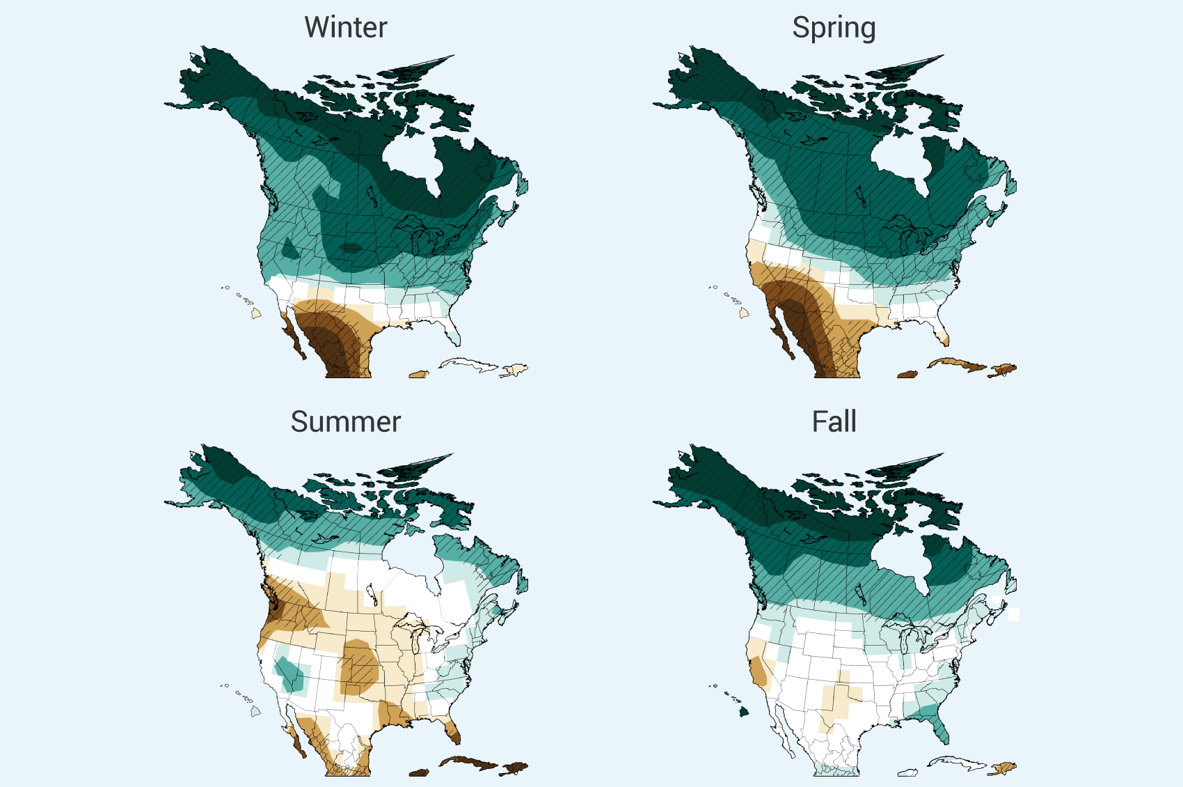
The patterns of precipitation change in the newer CMIP5 simulations are essentially the same as in the earlier CMIP3 and NARCCAP simulations used in impact analyses throughout this report, increasing confidence in our scientific understanding. The subtle differences between these two sets of projections are mostly due to the wider range of future scenarios considered in the more recent simulations. Thus, the overall picture remains the same: wetter conditions in the north and drier conditions in the Southwest in winter and spring. Drier conditions are projected for summer in most areas of the contiguous U.S. but, outside of the Northwest and south-central region, there is generally not high confidence that the changes will be large compared to natural variability. In all models and scenarios, a transition zone between drier (to the south) and wetter (to the north) shifts northward from the southern U.S. in winter to southern Canada in summer. Wetter conditions are projected for Alaska and northern Canada in all seasons.

Figure 2.15: Newer Simulations for Projected Precipitation Change (CMIP5 models)

Seasonal Precipitation

Rapid Emissions Reductions (RCP 2.6)Continued Emissions Increases (RCP 8.5)

Figure 2.15: Seasonal precipitation change for 2071-2099 (compared to 1970-1999) as projected by recent simulations that include a wider range of scenarios. The maps on the left (RCP 2.6) assume rapid reductions in emissions – more than 70% cuts from current levels by 2050 – and a corresponding much smaller amount of warming and far less precipitation change. On the right, RCP 8.5 assumes continued increases in emissions, with associated large increases in warming and major precipitation changes. These would include, for example, large reductions in spring precipitation in the Southwest and large increases in the Northeast and Midwest. Rapid emissions reductions would be required for the more modest changes in the maps on the left. Hatched areas indicate that the projected changes are significant and consistent among models. White areas indicate that the changes are not projected to be larger than could be expected from natural variability. (Figure source: NOAA NCDC / CICS-NC).

Details/Download

References

  1. Sarojini, B. Balan, P. A. Stott, E. Black, and D. Polson, 2012: Fingerprints of changes in annual and seasonal precipitation from CMIP5 models over land and ocean. Geophysical Research Letters, 39, L21706, doi:10.1029/2012GL053373. URL | Detail

  2. Groisman, P. Y., R. W. Knight, and T. R. Karl, 2012: Changes in intense precipitation over the central United States. Journal of Hydrometeorology, 13, 47-66, doi:10.1175/JHM-D-11-039.1. URL | Detail

  3. Held, I. M., and B. J. Soden, 2006: Robust responses of the hydrological cycle to global warming. Journal of Climate, 19, 5686-5699, doi:10.1175/jcli3990.1. URL | Detail

  4. Higgins, R. W., and V. E. Kousky, 2013: Changes in observed daily precipitation over the United States between 1950–79 and 1980–2009. Journal of Hydrometeorology, 14, 105-121, doi:10.1175/jhm-d-12-062.1. URL | Detail

  5. ,, 2007: Summary for Policymakers. Climate Change 2007: The Physical Science Basis. Contribution of Working Group I to the Fourth Assessment Report of the Intergovernmental Panel on Climate Change, S. Solomon, Qin, D., Manning, M., Chen, Z., Marquis, M., Averyt, K.B., Tignor, M., and Miller, H.L., Eds., Cambridge University Press, 1-18. URL | Detail

  6. Kunkel, K. E., L. E. Stevens, S. E. Stevens, L. Sun, E. Janssen, D. Wuebbles, and J. G. Dobson, 2013: Regional Climate Trends and Scenarios for the U.S. National Climate Assessment: Part 9. Climate of the Contiguous United States. NOAA Technical Report NESDIS 142-9. 85 pp., National Oceanic and Atmospheric Administration, National Environmental Satellite, Data, and Information Service, Washington, D.C. URL | Detail

  7. Kunkel, K. E. et al., 2013: Monitoring and understanding trends in extreme storms: State of knowledge. Bulletin of the American Meteorological Society, 94, doi:10.1175/BAMS-D-11-00262.1. URL | Detail

  8. McRoberts, D. B., and J. W. Nielsen-Gammon, 2011: A new homogenized climate division precipitation dataset for analysis of climate variability and climate change. Journal of Applied Meteorology and Climatology, 50, 1187-1199, doi:10.1175/2010JAMC2626.1. URL | Detail

  9. Peterson, T. C. et al., 2013: Monitoring and understanding changes in heat waves, cold waves, floods and droughts in the United States: State of knowledge. Bulletin of the American Meteorological Society, 94, 821-834, doi:10.1175/BAMS-D-12-00066.1. URL | Detail

  10. Polson, D., G. C. Hegerl, X. Zhang, and T. J. Osborn, 2013: Causes of robust seasonal land precipitation changes. Journal of Climate, 26, 6679-6697, doi:10.1175/JCLI-D-12-00474.1. URL | Detail

  11. Vose, R. S. et al., 2013: Monitoring and understanding changes in extremes: Extratropical storms, winds, and waves. Bulletin of the American Meteorological Society, in press, doi:10.1175/BAMS-D-12-00162.1. URL | Detail

  12. Wuebbles, D. J., G. Meehl, K. Hayhoe, T. R. Karl, K. Kunkel, B. Santer, M. Wehner, B. Colle, E. M. Fischer, R. Fu, A. Goodman, E. Janssen, H. Lee, W. Li, L. N. Long, S. Olsen, A. J. Sheffield, and L. Sun, 2013: CMIP5 climate model analyses: Climate extremes in the United States. Bulletin of the American Meteorological Society, in press, doi:10.1175/BAMS-D-12-00172.1. URL | Detail

The National Climate Assessment summarizes the impacts of climate change on the United States, now and in the future.

A team of more than 300 experts guided by a 60-member Federal Advisory Committee produced the report, which was extensively reviewed by the public and experts, including federal agencies and a panel of the National Academy of Sciences.

United States Global Change Research Program logo United States Global Change Research Program participating agency logos