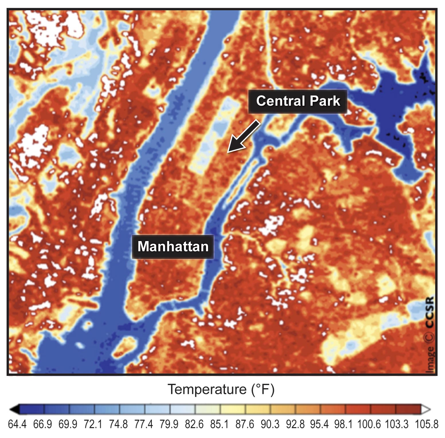
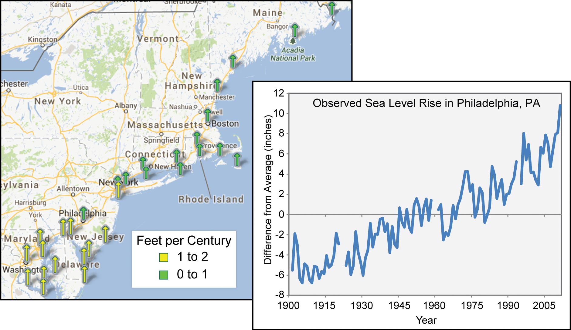
This website is the digital version of the 2014 National Climate Assessment, produced in collaboration with the U.S. Global Change Research Program.

For the official version, please refer to the PDF in the downloads section. The downloadable PDF is the official version of the 2014 National Climate Assessment.

Credits | Site Map

Search Options

X

Search form

Top

Welcome to the National Climate Assessment

The National Climate Assessment summarizes the impacts of climate change on the United States, now and in the future.

A team of more than 300 experts guided by a 60-member Federal Advisory Committee produced the report, which was extensively reviewed by the public and experts, including federal agencies and a panel of the National Academy of Sciences.

Explore the effects of climate change
United States Global Change Research Program logo
United States Department of Agriculture logo United States Department of Commerce logo United States Department of Defense logo United States Department of Energy logo United States Department of Health and Human Services logo United States Department of the Interior logo United States Department of State logo United States Department of Transportation logo United States Environmental Protection Agency logo National Aeronautics and Space Administration logo National Science Foundation logo Smithsonian Institution logo United States Agency for International Development logo

Northeast

Heat waves, heavy downpours, and sea level rise pose growing challenges to many aspects of life in the Northeast. Infrastructure, agriculture, fisheries, and ecosystems will be increasingly compromised. Many states and cities are beginning to incorporate climate change into their planning.

Explore how climate change is affecting the Northeast.

Next

Introduction

The Northeast region includes the states of Connecticut, Delaware, Maine, Maryland, Massachusetts, New Hampshire, New Jersey, New York, Pennsylvania, Rhode Island, Vermont, West Virginia, and the District of Columbia. The Highlights section below offers a high-level overview of climate change impacts on this region, including the four Key Messages and selected topics. (see Ch. 16: Northeast)

Key Message: Climate Risks to People

Heat waves, coastal flooding, and river flooding will pose a growing challenge to the region’s environmental, social, and economic systems. This will increase the vulnerability of the region’s residents, especially its most disadvantaged populations.

Key Message: Stressed Infrastructure

Infrastructure will be increasingly compromised by climate-related hazards, including sea level rise, coastal flooding, and intense precipitation events.

Key Message: Agricultural and Ecosystem Impacts

Agriculture, fisheries, and ecosystems will be increasingly compromised over the next century by climate change impacts. Farmers can explore new crop options, but these adaptations are not cost- or risk-free. Moreover, adaptive capacity, which varies throughout the region, could be overwhelmed by a changing climate.

Key Message: Planning and Adaptation

While a majority of states and a rapidly growing number of municipalities have begun to incorporate the risk of climate change into their planning activities, implementation of adaptation measures is still at early stages.

Northeast

Sixty-four million people are concentrated in the Northeast. The high-density urban coastal corridor from Washington, D.C., north to Boston is one of the most developed environments in the world. It contains a massive, complex, and long-standing network of supporting infrastructure. The Northeast also has a vital rural component, including large expanses of sparsely populated but ecologically and agriculturally important areas.

Urban Heat Island Urban Heat Island Details/Download

Although urban and rural regions in the Northeast are profoundly different, they both include populations that are highly vulnerable to climate hazards and other stresses. The region depends on aging infrastructure that has already been stressed by climate hazards including heat waves and heavy downpours. The Northeast has experienced a greater recent increase in extreme precipitation than any other region in the U.S.; between 1958 and 2010, the Northeast saw more than a 70% increase in the amount of precipitation falling in very heavy events (defined as the heaviest 1% of all daily events).1 This increase, combined with coastal and riverine flooding due to sea level rise and storm surge, creates increased risks. For all of these reasons, public health, agriculture, transportation, communications, and energy systems in the Northeast all face climate-related challenges.

Hurricane Vulnerability

Hurricanes Irene and Sandy demonstrated the region’s vulnerability to extreme weather events and the potential for adaptation to reduce impacts. Hurricane Irene produced a broad swath of very heavy rain (greater than 5 inches in total and 2 to 3 inches per hour in some locations) from southern Maryland to northern Vermont from August 27 to 29, 2011. These heavy rains were part of a broader pattern of wet weather preceding the storm that exacerbated the flooding.

In anticipation of Irene, the New York City mass transit system was shut down, and 2.3 million coastal residents in Delaware, New Jersey, and New York faced mandatory evacuations. But inland impacts, especially in upstate New York and in central and southern Vermont, were most severe. Flash flooding washed out roads and bridges, undermined railroads, brought down trees and power lines, flooded homes and businesses, and damaged floodplain forests. Hazardous wastes were released in a number of areas, and 17 municipal wastewater treatment plants were breached by the floodwaters. Crops were flooded and many towns and villages were isolated for days.

Sea Level is Rising Sea Level is Rising Details/Download

Hurricane Sandy, which hit the East Coast in October 2012, caused massive coastal damage from storm surge and flooding. Sandy was responsible for approximately 150 deaths, about half of those in the Northeast, and monetary impacts on coastal areas, especially in New Jersey, New York, and Connecticut estimated at $60 to $80 billion.3,4 Floodwaters inundated subway tunnels in New York City, 8.5 million people were without power, and an estimated 650,000 homes were damaged or destroyed.3

Selected Adaptation Efforts

park in Philadelphia

This one-acre stormwater wetland was constructed in Philadelphia to treat stormwater runoff in an effort to improve drinking water qualitify while minimizing the impacts of storm-related flows on natural ecosystems.

The City of Philadelphia is greening its combined sewer infrastructure to protect rivers, reduce greenhouse gas emissions, improve air quality, and enhance adaptation to a changing climate.5

Officials in coastal Maine are working with the statewide Sustainability Solutions Initiative to identify how culverts that carry stormwater can be maintained and improved, in order to increase resiliency to more frequent extreme precipitation events. This includes actions such as using larger culverts to carry water from major storms.6

References

  1. Blake, E. S., T. B. Kimberlain, R. J. Berg, J. P. Cangialosi, and J. L. Beven, II, 2013: Tropical Cyclone Report: Hurricane Sandy. (AL182012) 22 – 29 October 2012. 157 pp., National Oceanic and Atmospheric Administration, National Hurricane Center. URL | Detail

  2. Groisman, P. Y., R. W. Knight, and O. G. Zolina, 2013: Recent trends in regional and global intense precipitation patterns. Climate Vulnerability, R.A. Pielke, Sr., Ed., Academic Press, 25-55. | Detail

  3. Jain, S., E. Stancioff, and A. Gray, 2012: Coastal Climate Adaptation in Maine’s Coastal Communities: Governance Mapping for Culvert Management. URL | Detail

  4. ,, 2013: Sea Level Trends. National Oceanic and Atmospheric Administration, National Ocean Service. URL | Detail

  5. ,, 2013: Billion Dollar Weather/Climate Disasters, List of Events. National Oceanic and Atmospheric Administration. URL | Detail

  6. ,, 2013: Green City, Clean Waters. Philadelphia Water Department. URL | Detail

The National Climate Assessment summarizes the impacts of climate change on the United States, now and in the future.

A team of more than 300 experts guided by a 60-member Federal Advisory Committee produced the report, which was extensively reviewed by the public and experts, including federal agencies and a panel of the National Academy of Sciences.

United States Global Change Research Program logo United States Global Change Research Program participating agency logos