Introduction
Over the past few years, the focus moved from the question “Is climate changing?” to the equally important question: “Can society manage unavoidable changes and avoid unmanageable changes?”225,191 Research demonstrates that both mitigation (efforts to reduce future climate changes) and adaptation (efforts to reduce the vulnerability of society to climate change impacts) are needed in order to minimize the damages from human-caused climate change and to adapt to the pace and ultimate magnitude of changes that will occur.226,188,189,13
Adaptation and mitigation are closely linked; adaptation efforts will be more difficult, more costly, and less likely to succeed if significant mitigation actions are not taken.191,187 The study and application of adaptation in the climate change realm is nascent compared to the many analyses of mitigation policies and practices to reduce emissions. Uncertainties about future socioeconomic conditions as well as future climate changes can make it difficult to arrive at adaptation decisions now. However, the pace and magnitude of projected change emphasize the need to be prepared for a wide range and intensity of climate impacts in the future. Planning and managing based on the climate of the last century means that tolerances of some infrastructure and species will be exceeded.13,104,3 For example, building codes and landscaping ordinances will likely need to be updated not only for energy efficiency but also to conserve water supplies, protect against disease vectors, reduce susceptibility to heat stress, and improve protection against extreme events.13,1 Although there is uncertainty about future conditions, research indicates that intelligent adaptive actions can still be taken now.124,4 Climate change projections have inherent uncertainties, but it is still important to develop, refine, and deploy tools and approaches that enable iterative decision-making and increase flexibility and robustness of climate change responses (Ch. 2: Our Changing Climate).227,228
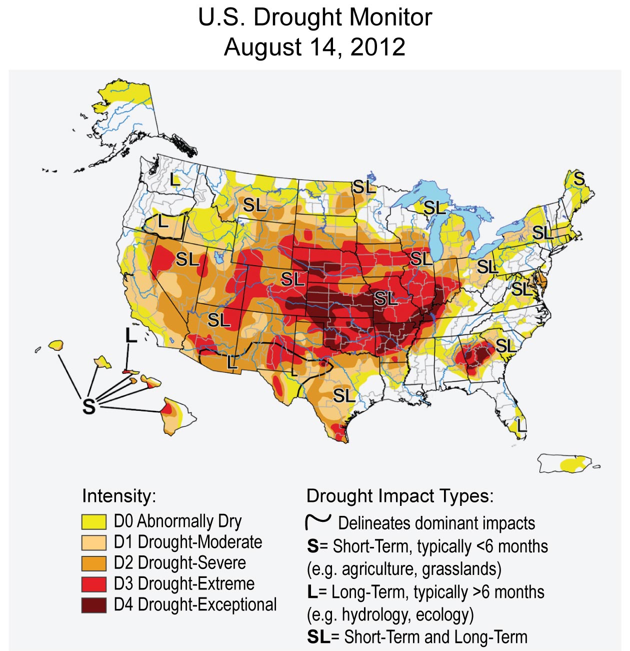
Climate change affects human health, natural ecosystems, built environments, and existing social, institutional, and legal arrangements. Adaptation considerations include local, state, regional, national, and international issues. For example, the implications of international arrangements need to be considered in the context of managing the Great Lakes, the Columbia River, and the Colorado River to deal with drought.2,125 Both “bottom up” community planning and “top down” national strategies4 may help regions deal with impacts such as increases in electrical brownouts, heat stress, floods, and wildfires. Such a mix of approaches will require cross-boundary coordination at multiple levels as operational agencies integrate adaptation planning into their programs.
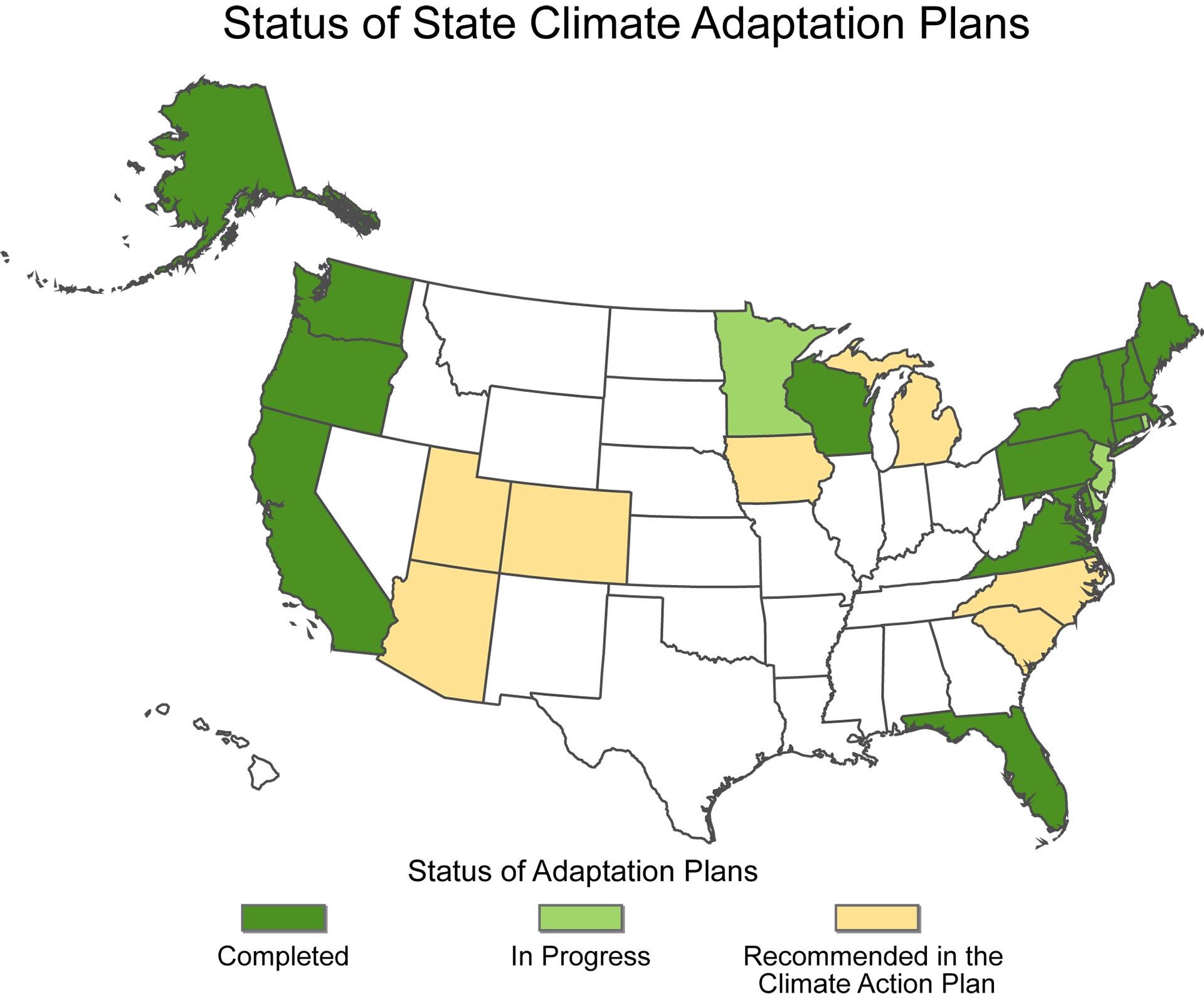
Adaptation actions can be implemented reactively, after changes in climate occur, or proactively, to prepare for projected changes.4 Proactively preparing can reduce the harm from certain climate change impacts, such as increasingly intense extreme events, shifting zones for agricultural crops, and rising sea levels, while also facilitating a more rapid and efficient response to changes as they happen. This chapter highlights efforts at the federal, regional, state, tribal, and local levels, as well as initiatives in the corporate and non-governmental sectors to build adaptive capacity and resilience in response to climate change. While societal adaptation to climate variability is as old as civilization itself,229 the focus of this chapter is on preparing for unprecedented human-induced climate change through adaptation. A map of illustrative adaptation activities and four detailed case examples that highlight ongoing adaptation activity across the U.S. are provided in Section 4 of this chapter.
Adaptation Key Terms Definitions*
Adapt, Adaptation: Adjustment in natural or human systems to a new or changing environment that exploits beneficial opportunities or moderates negative effects.
Adaptive Capacity: The potential of a system to adjust to climate change (including climate variability and extremes) to moderate potential damages, take advantage of opportunities, and cope with the consequences.
Mitigation: Technological change and substitutions that reduce resource inputs and emissions per unit of output. Although several social, economic, and technological actions would reduce emissions, with respect to climate change, mitigation means implementing actions to reduce greenhouse gas emissions or increase the amount of carbon dioxide absorbed and stored by natural and man-made carbon sinks (see Ch. 27: Mitigation).
Multiple Stressors: Stress that originates from different sources that affect natural, managed, and socioeconomic systems and can cause impacts that are compounded and sometimes unexpected. An example would be when economic or market stress combines with drought to negatively impact farmers.
Resilience: A capability to anticipate, prepare for, respond to, and recover from significant multi-hazard threats with minimum damage to social well-being, the economy, and the environment.
Risk: A combination of the magnitude of the potential consequence(s) of climate change impact(s) and the likelihood that the consequence(s) will occur.
Vulnerability: The degree to which a system is susceptible to, or unable to cope with, adverse effects of climate change, including climate variability and extremes. Vulnerability is a function of the character, magnitude, and rate of climate variation to which a system is exposed, its sensitivity, and its adaptive capacity.